The Arkansas River Trail: Complete Guide for Cyclists and Walkers
The Arkansas River Trail is the crown jewel of Little Rock's outdoor recreation scene. This 88-mile loop of paved and natural-surface trails connects Little Rock, North Little Rock, Maumelle, and Conway, offering world-class cycling, walking, and running along the beautiful Arkansas River. Here's your complete guide to the Arkansas River Trail.
Overview
The Arkansas River Trail (ART) is a multi-use trail system that forms a massive loop along both banks of the Arkansas River. The trail crosses the river via several iconic bridges, including the Big Dam Bridge and the Junction Bridge, creating a continuous route through some of the most scenic landscapes in central Arkansas.
Key Sections
Big Dam Bridge Section
Distance: 2 miles (bridge + approaches) | Difficulty: Easy | Surface: Paved
The Big Dam Bridge is the trail's most iconic feature — at over 4,000 feet, it's the longest bridge in North America built specifically for pedestrians and cyclists. The gentle grade makes it accessible for all fitness levels, and the views of the Arkansas River and Pinnacle Mountain are spectacular, especially at sunset.
Two Rivers Park to Pinnacle Mountain
Distance: ~5 miles | Difficulty: Easy | Surface: Paved
This beautiful section winds through Two Rivers Park at the confluence of the Arkansas and Little Maumelle Rivers, then continues along the river toward Pinnacle Mountain State Park. Flat, wide, and scenic — perfect for families and casual riders.
Murray Park to Clinton Library
Distance: ~3 miles | Difficulty: Easy | Surface: Paved
This urban section runs along the south bank of the Arkansas River through downtown Little Rock. Pass Riverfront Park, the Clinton Presidential Library, and enjoy city skyline views across the water.
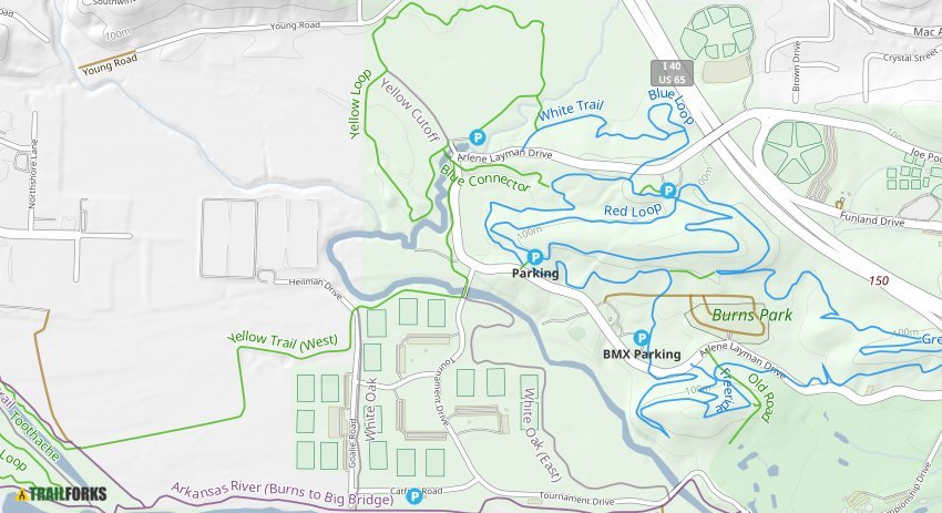
Burns Park Section (North Little Rock)
Distance: ~6 miles | Difficulty: Easy to Moderate | Surface: Paved and natural
The trail through Burns Park offers both paved paths and natural-surface singletrack options. This section is popular with cyclists and runners and connects to the park's extensive mountain biking trails.
Maumelle to Conway Extension
Distance: ~20 miles | Difficulty: Moderate | Surface: Mixed
The newest extension of the ART stretches from Maumelle toward Conway, passing through rural landscape and offering longer ride opportunities. Some sections are still under development.
Essential Information
Access Points
• Two Rivers Park — Large parking area, restrooms, water fountains
• Murray Park — Downtown access, parking, picnic areas
• Big Dam Bridge — Parking on both the Little Rock and North Little Rock sides
• Burns Park — Multiple trailheads with parking
• Pinnacle Mountain State Park — Park at the visitor center
Rules and Etiquette
• Cyclists yield to pedestrians
• Keep right, pass left
• Announce when passing ("On your left!")
• Dogs must be leashed
• No motorized vehicles (e-bikes under 750W are permitted)
• Stay on designated trails
Best Times to Ride or Walk
- Early morning (6–9 AM): Beat the heat and crowds. Best light for photos.
• Sunset: The Big Dam Bridge at sunset is a Little Rock bucket-list experience.
• Weekdays: Significantly less traffic than weekends.
• Fall and Spring: Perfect temperatures for longer rides and walks.
What to Bring
- Water bottle (refill stations are limited on some sections)
• Sunscreen and sunglasses
• Bike lock if making stops
• Flat repair kit for cyclists
• Phone for navigation (the trail has some confusing intersections)
Bike Rentals and Shops
Don't have a bike? No problem. Several shops near the trail offer rentals:
• Bobby's Bike Hike — Rentals and guided tours from downtown
• Angry Dave's Bicycles — Full-service shop with rental options
• Rock Town River Outfitters — Multi-sport rentals
Check our directory for all bike rental locations and shops.
Fun Facts
- The ART has been named one of the best urban trails in the United States
• The Big Dam Bridge sits atop Murray Lock and Dam on the Arkansas River
• The trail system has generated significant economic development along its route
• Over 1 million users enjoy the trail annually
Ready to Explore?
The Arkansas River Trail is one of Little Rock's greatest assets — and it's free to use. Grab your bike, lace up your shoes, or just take a stroll. Check our Trail Directory for maps, current conditions, and more.
Pro tip: Download the Arkansas River Trail app for GPS-guided navigation and points of interest along the route.